PerúSAT-1: Five years serving Peru
Today marks the fifth anniversary of the launch of PerúSAT-1, Perus first satellite
By the end of August 2021 and five years after its launch, more than 67,000 PerúSAT-1 images have been distributed to more than 500 Peruvian institutions, generating an important contribution to their work at national level. The information delivered by these images is vital for various sectors such as crop monitoring, disaster risk management, road monitoring, and security. It works together with other satellites that make up the Peruvian Satellite System.
On 15 September 2016, the high resolution Earth observation satellite, PerúSAT-1 was launched from the Kourou spaceport in French Guiana, aboard a Vega launcher. At the Pucusana satellite control centre and throughout the country, Peru celebrated its entry into space. From day one, the satellite has been controlled by Peruvian specialists and engineers from the National Centre for Satellite Image Operations (Centro Nacional de Operaciones de Imágenes Satelitales, CNOIS).
All the users of the satellite system have generated products that benefit the population; especially in Disaster Risk Management, a very important sector in our country. Likewise, we must continue working to maintain our presence in space, since we have shown, and the user institutions confirm it, how important satellite information is in decision-making, said FAP Major General José Antonio García Morgan, institutional head of the Peruvian Space Agency.
PerúSAT-1 was built by Airbus Defence and Space in a record time of two years and orbits the Earth at an altitude of 702.5 km, acquiring up to 300 images a day, providing Peru with the most advanced optical satellite in the region. By design, a further five years of useful life remain; however, specialists from the Space Agency calculate that a few additional years will be possible depending on fuel and manoeuvres performed.
It is a great pleasure for us to celebrate this important date with our clients and friends in Peru, said Jean Marc Nasr, Head of Space Systems at Airbus. We committed to deliver a complete state-of-the-art system to help develop Perus space capabilities and these first five years bear witness to this. Peru can continue to count on the best of our satellite technology in the future.
In addition to the latest-generation optical satellite, the PerúSAT-1 programme included a ground segment for control, reception and processing of images, located at CNOIS in Pucusana and also built by Airbus Defence and Space. The project developed Peruvian skills in space technologies, satellite operation and applications for image processing. In total, more than 80 Peruvian specialists benefited from this technology transfer programme, both in Toulouse and Lima.
Many Peruvian institutions work with satellite information including the National Civil Defence Institute (INDECI), the National Commission for Development and Life without Drugs (DEVIDA), the Ministry of Transport and Communications (MTC), the National Forest Service (SERFOR), the National Centre for the Estimation, Prevention and Reduction of Disaster Risk (CENEPRED), the Geological, Mining and Metallurgical Institute (INGEMMET), the Ministry of Agrarian Development and Irrigation (MIDAGRI), the Armed Forces, the Ministry of the Environment (MINAM), the National Geographic Institute (IGN), the National Service of Natural and Protected Areas by the State (SERNANP), and the Environmental Assessment and Enforcement Agency (OEFA), among others.
About Airbus
Airbus pioneers sustainable aerospace for a safe and united world. The Company constantly innovates to provide efficient and technologically-advanced solutions in aerospace, defence, and connected services. In commercial aircraft, Airbus offers modern and fuel-efficient airliners and associated services. Airbus is also a European leader in defence and security and one of the worlds leading space businesses. In helicopters, Airbus provides the most efficient civil and military rotorcraft solutions and services worldwide.
About CONIDA
The National Commission for Aerospace Research and Development is the body that governs activities related to space research and development in Peru, as well as being the headquarters of the Peruvian Space Agency.
----
IMAGE CAPTION:
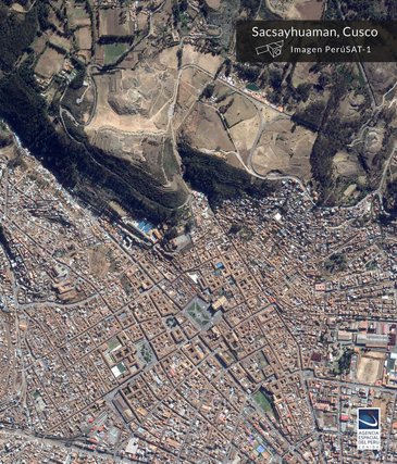
Sacsayhuaman CUSCO
By the end of August 2021 and five years after its launch, more than 67,000 PerúSAT-1 images have been distributed to more than 500 Peruvian institutions, generating an important contribution to their work at national level. The information delivered by these images is vital for various sectors such as crop monitoring, disaster risk management, road monitoring, and security. It works together with other satellites that make up the Peruvian Satellite System.
( Press Release Image: https://photos.webwire.com/prmedia/6/279105/279105-1.jpg )
WebWireID279105
This news content was configured by WebWire editorial staff. Linking is permitted.
News Release Distribution and Press Release Distribution Services Provided by WebWire.