Smithsonian To Install Mile-Marker Post From Dakota Access Pipeline Protest Site in Exhibition on Treaties
The Smithsonians National Museum of the American Indian will add to its exhibition on treaties, Nation to Nation: Treaties Between the United States and American Indian Nations, an 11.5-foot-tall mile-marker post created by activists who came to North Dakota to protest the Dakota Access Pipeline. The mile-marker will be previewed for press Tuesday, Oct. 24, at 9:30 a.m. in the exhibition space on the fourth floor. It will be on view for visitors once the museum opens later that morning.
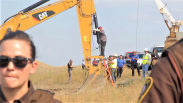
When more than 12,000 activists and hundreds of Native Nations assembled in North Dakota during 2016 to protest the Dakota Access Pipeline, treaties were at the heart of the issue, said Kevin Gover, director of the museum. As the largest gathering of Native Americans in protest, it was truly a historic event and one that should be addressed in the National Museum of the American Indian.
Gover will speak at the press event.
The Horse Creek (Fort Laramie) Treaty of 1851, recently displayed in the museum on loan from the National Archives and Records Administration (National Archives), defined the lands of the Sioux. An 1868 treaty and acts of Congress revised the boundaries but guaranteed the Tribe absolute and undisturbed use and occupation of their territory.
The Standing Rock Sioux Tribe claimed that the U.S. Army Corps of Engineers rejected the private pipelines original route because an oil spill could foul the drinking water of Bismarck and then approved a new route through ancestral land without adequate consultation. Indigenous people and their allies from around the globe joined the Standing Rock Sioux Tribes protest. They called themselves water protectors and established three camps near the pipelines planned crossing under the Missouri River. The mile-marker post stood on the largest one, the Oceti Sakowin (Great Sioux Nation) camp.
The mile-marker post was constructed by many of the water protectors to show how far they had travelled. Hundreds of hand-made signs nailed to the post point toward the water protectors city, state, American Indian Nation, or foreign country and indicate its distance in miles or meters. Points of origin include the small city of Fort Buffalo 50 yards away, the closest, to Sápmi in the Arctic, home of the Sami indigenous peoples, 3,913 miles away.
When the camp was shutting down in 2017, Hickory Edwards (Onondaga), one of the water protectors, took the mile-marker post with him with the intention of donating it to the National Museum of the American Indian. The post will remain on view for the duration of the exhibitionthrough 2021.
Most Americans live on land that was promised to Native Nations through treaties. The U.S. Senate ratified more than 370 treaties between the United States and American Indian Nations. About 250 more executive orders and acts of Congress had much of the same legal effect of treaties. The Nation to Nation exhibition focuses on historic episodes of treaty-making, how promises were kept and broken, and in some cases renewed, with American Indian Nations.
The National Museum of the American Indian is committed to advancing knowledge and understanding of the Native cultures of the Western Hemispherepast, present and futurethrough partnership with Native people and others. Located on the National Mall at Fourth Street and Independence Avenue S.W., the museum is open each day from 10 a.m. to 5:30 p.m. (closed Dec. 25). It is accessible from LEnfant Plaza Metrorail station via the Maryland Avenue/Smithsonian Museums exit.
( Press Release Image: https://photos.webwire.com/prmedia/6/214875/214875-1.png )
WebWireID214875
This news content was configured by WebWire editorial staff. Linking is permitted.
News Release Distribution and Press Release Distribution Services Provided by WebWire.